Yesterday we saw the image of a 500hPa air pressure configuration in the Arctic that was badly distorted for this time of year, and what the consequences were like. The major jetstream pathways defined by the outer borders of the blue zone and the green zone were likewise distorted, thereby altering the normal behavior of precipitable water (PW) activity over a large portion of the upper Northern Hemisphere. This alteration in turn paved the way for a number of extreme temperature anomalies to appear, both warm and cold. One of the very warm ones, also quite large in size, penetrated into the heart of the polar zone, where its effects can do great damage. A similar event is being reported today, for the same basic set of reasons.
Today I want to provide an illustration of what things could be like at this time in a presumably more normal year, for which I have no recorded images to offer. What I do have is imagery of the current situation at the other pole, which is now flooded with sunlight and heading into the peak of the warming season, yet still has some power of analogy. I also want to extend the practice of comparing the 500hPa pressure imagery for the two regions around the end of each month, as they proceed through their opposing year-long transitions. The NH imagery became badly decomposed last summer and has been unable to complete a full seasonal comeback. The current warm spell will make that comeback all the more difficult, just because the 500hPa pressures are highly sensitive to surface temperatures that would otherwise be much colder. By contrast, the SH remained as steady as a rock all through its winter season and has been reluctant to give up its frozen signature ever since. Now compare this current image in the SH with the one from yesterday in the north:
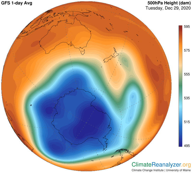
With one exception, this shows you what an ordinarily compact blue zone looks like, and see how the green zone easily retains its own compact shape as a result. That means the two major jetstream pathways are both able to stay in place and remain at full strength over more than half of their total circumference. The remaining sections have been shuffled by only a minor extent, leaving a single blister in the lower right that is no more than ordinary for this time of year. Let’s see what this all means for actual jetstream wind expression:
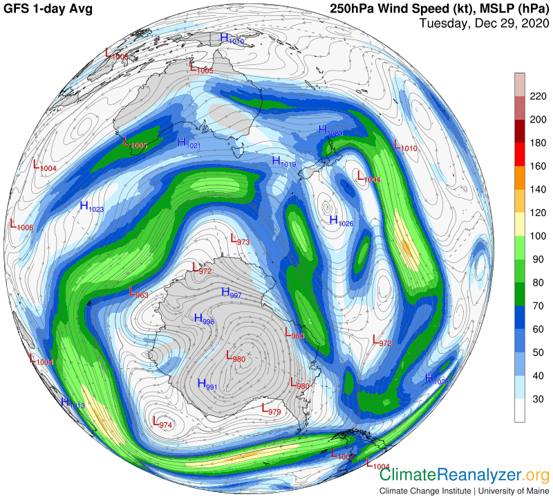
There are definitely some weak spots in place that can facilitate penetration by PW streams, but certainly not in a wide-open way, so let’s open the PW map and see the result:
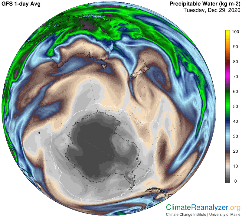
There is plenty of PW in the air encircling the continent, and some penetration, but nothing deep. My letters carry images of how the same season was developing in the north as of last June, with profound differences in the outcome. When PW is being held back like it is here there is not much chance for extreme anomalies of any kind to form, so this is what we are likely to get instead:
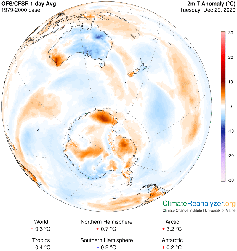
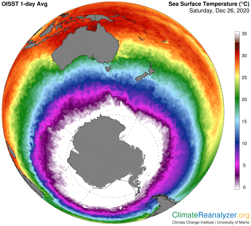
We can’t leave this scene without taking note of the vast amount of cold anomaly presently covering the oceanic parts of the SH. With all of the PW concentrations hanging around in the air overhead why do these areas not show more warming? I don’t have a firm opinion to offer, but think it is at least possible that an unusual amount of ice in the form of large bergs is drifting around in these waters and not melting very rapidly. I will throw in one more image showing how substantial amounts of this surface water is carrying temperatures right at zero, or only a little bit more, which is not exactly seasonal and not conducive to melting. The bergs themselves in some cases are known to be quite large and have interior parts that are many degrees below zero. Getting everything fully melted can thus take up more than a usual fair share of incoming energy, and the outcome might very well be enough to cause the net shifting of water temperature as we see it. It also suggests that this entire part of the world could remain in a relatively cool state for years to come if, as some predict, the Antarctic ice sheet breaks down further and faster. How this would affect the rapidly warming north is none too clear.
Carl