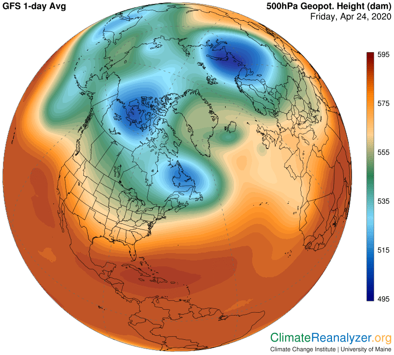
The Weather Maps are full of abnormalities today. Let’s take a look, starting with the one that possibly holds the key, the 500hPa map. (This is the map that is hardest of all for anyone to understand and get used to. Some recent letters may be helpful if you are having trouble.) The main thing to notice here is the fragmentation of the lowest pressure area into separate pieces such that each ends up with its own light blue ring, marking an extra-large upward step in the gradient of air pressure change and higher wind speeds that trend alongside that step. This fragmentation has profound effects on the innermost jetstream wind pathway and its relationship to the two others, as described in recent letters, leading to the badly scrambled jets that were pictured at the end of yesterday’s letter.
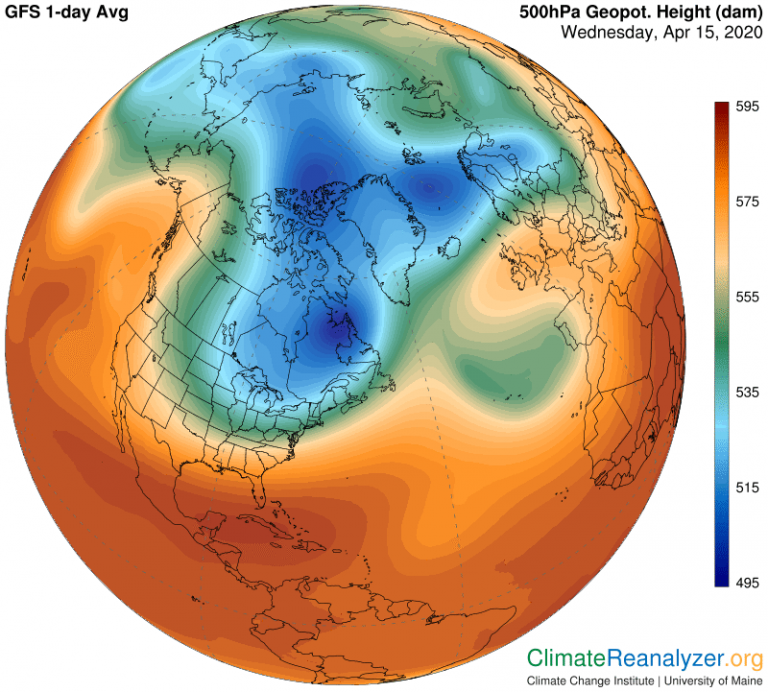
Now we’ll look at the same view as it appeared only nine days ago. At that time the blue zone was already showing signs of distortion from normal, which would have usually given it a more rounded and unified look, or more like what we regularly observe over the South polar region.
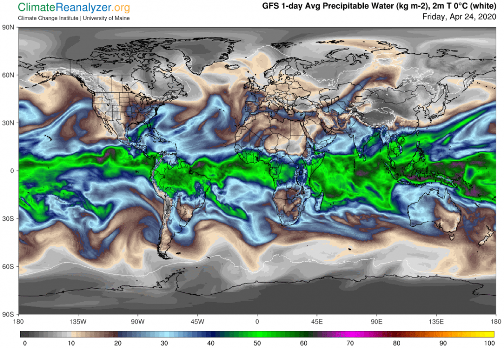
What are the consequences? Most directly, big changes in jetstream winds, which today are more scrambled than ever, with more and more bits and pieces of the speedier parts appearing right over the Arctic Ocean, close to the pole. When jetstream winds lose their integrity this way they lose their ability to resist the encroachment of streams of airborne water molecules that are always behaving about like those great explorers who made reaching the pole a lifetime goal. Water molecules almost always fall short of that goal, thanks to how the jets are positioned, but when the jets get scrambled things change and the water is more free to move. By comparison, all the water vapor now seeking to reach the South Pole is facing better organized resistance. This is how it all looks on the Precipitable Water map, where special attention should first be given to the brown-colored track that crosses Siberia and continues carrying a heavy load up to and beyond the 80N parallel. A second large pulse of airborne water, not quite as massive, has moved north over the Atlantic, where a reduced part of it was able to curl around the top of Greenland:
There is one final, dramatic consequence in this chain of events. Water vapor is by far the most powerful greenhouse gas, and at the same time by far the most variable with respect to its content by weight within any given body of air—extremely so in fact, covering a range, on any given day, from well under one kilogram to somewhat over 70. Approaching either pole, “normal” content is always very near the bottom of the scale, like 1-2 kg, or less. When air with higher values comes flowing in or over, at no matter what altitude, local air temperatures must go up, and they do so at once. How far up? By a maximum of 10C whenever there is a double in the kg value, with reductions from the maximum mostly dependent on the amount of cloud cover during the day. This, so far, is the result:
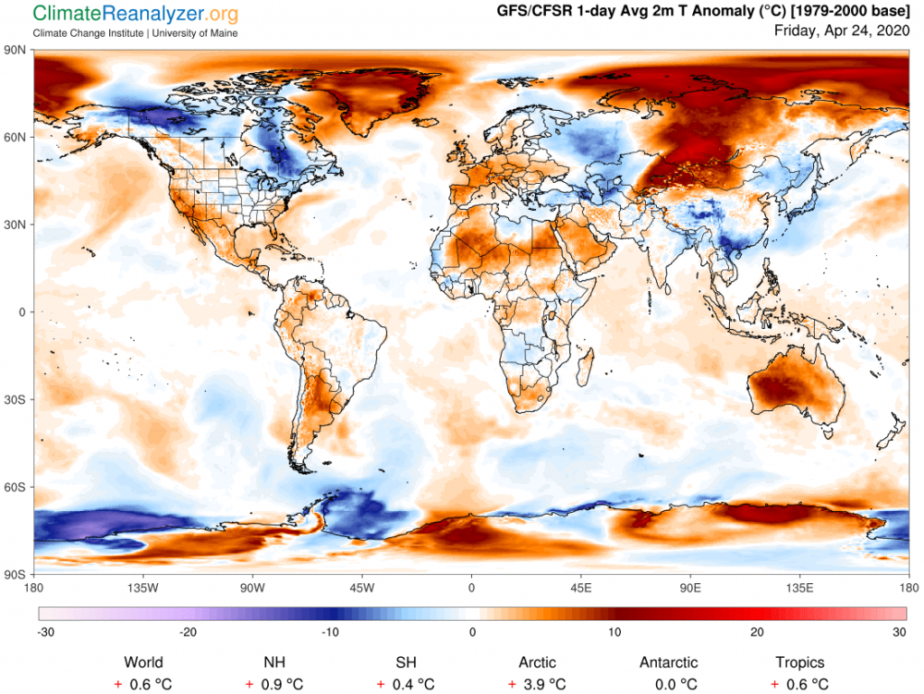
One of the things we will be looking for in the near future is whether the breakdown in the upper level air pressure pattern, which badly messes up the jetstream winds, can be repaired at any time soon. If not, more of the same high-North temperature extremes can be expected as the hemisphere as a whole warms toward a summer peak. One can also wonder about any possible significance related to the distant future, or to the south as well as the north, where the momentary temperature anomaly spread is an astonishing 3.9C.
Carl