In yesterday’s letter I started something that left me wondering about how, or whether, to continue on that course with more regularity. It could mean making substantial changes in the content of these letters, which might be refreshing to some readers but bothersome to others. In my mind the answer is now clear—make the change, for one good reason. I have been taking time to study Today’s Weather Maps, a section of The Climate Reanalyzer, published daily by a department of the University of Maine, for four or five years now, and have made comments here on their content any number of times. The information they contain is almost entirely visual, which is perfectly fine by me. The amount of information is absolutely enormous, clearly presented and easy to absorb. Moreover, I have never found a reason to question its accuracy. And the way the information is broken down into a number of maps, all laid out within the same general format, allows correspondences to easily be observed, facilitated by the neat technique for fast toggling and switching that I described in some detail yesterday. The opportunities for making connections are unbounded, and the kind of information that can be constructed from that simple procedure will not always be found to have content of a familiar type. That suggests the possibility of its’ having real value in some cases.
It has occurred to me that perhaps not many individuals have been going about this particular activity in a regular way, as I have been doing, or are even aware of the opportunities for learning new things. If they exist we never hear from them, at least not in any of the publications, including scientific studies, that are out there for review every day. More people ought to become more engaged, and if I can help to promote a higher level of interest the effort may prove to be worthwhile in unexpected ways. So I am going to make more use of these letters as a kind of teaching platform, however rough it may be, in an attempt to get others involved. If you are not personally comfortable with this kind of activity perhaps you know someone who might be, and could provide them with a reference. Old or young makes no difference. Retired scientists from any field of study, looking for a new challenge, would be great.
Now I want to do a quick follow-up on the exercise recommended yesterday, dealing with knowledge about the operations of the jetstream, or rather, the three major jetstream pathways, each of them independent from the others, bearing wind currents that are highly spasmodic in pulses of speed, and which sometimes interconnect in a way that produces greatly accelerated velocities. The Weather Maps have a unique capability for displaying the exact locations of these pathways, and the exact conditions required for their presence in those locations, all tightly connected to upper atmosphere changes in air pressure. You will need to do this exercise quite often in order to become proficient in gaining a full understanding of what can only be thought of as superficial in character, yet serving as an essential prerequisite for going forward. Let’s open up the two most appropriate maps, as published today, which exhibit a bit of difference from similar images seen yesterday, and then mention a few pointers.
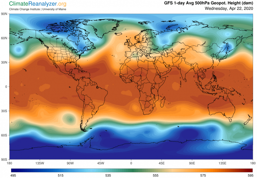
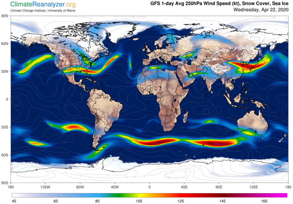
Following all of the instructions given yesterday, you can go to a live screen and toggle back and forth between these same two images, and with a little practice, gain the ability to look at either screen on any given day and form a prediction of what will be found on the other with respect to certain specific features and locations. But first, let me show you some things to look for as found in the above two images. For example, in the upper screen shot, while looking at the southern region, check out the shifting relationship between the upper edge of the thin blue streak and the upper edge of dark green streak, representing two of the three principal jetstream wind pathways. See how they are closest together at regions having locations identified by certain meridians, such as those which are centered at about 10E and 90E. This closeness is enough to enable an overlap that produces strong bursts of wind acceleration, at once verified by looking at the other chart. You can actually predict either of these features just by looking at the other, because the connection never fails! There is also an easily spotted spread in the gap between the same two pathways at around 45E, that should let you predict a corresponding gap between the two strong jets at that point, and there it is. This same kind of relationship holds from one end of this pair of lines to the other, along with imagery of all the bends and twists that occur with direction changes. See how the close relationship completely falls apart to the east of 135E, but at that same point the green pathway and the dark red pathway to its north close in on each other enough to create a small jet that you see in bright yellow just under Australia. The dark red pathway gets an even stronger reaction when it encounters the anomalous patch of plain green shaped like a ball at 90W.
The dark red pathway is a bit of an outlier compared to the blue and green ones, but still quite powerful. As an added consideration, it appears that wherever the red is deepest and darkest the associated wind along either of its edge-lines (north side or south side of the large red zone) will be the strongest. There is today a feature in the north where the edge area of the red zone is very dark over a long stretch just below the United States, and not too distant from the northern green edge, generating a fairly strong burst of jetting. Discovering these relationships can be thought of as an adventure, one that you may find not lacking for its own brand of excitement.
Carl