I have been looking at the 5-day animation of precipitable water (PW) this morning at http://tropic.ssec.wisc.edu/real-time/mtpw2/product.php and see something of interest which I can only describe in words. In the Northern Hemisphere there are now effectively just two streams breaking free from the tropics, one from the center of the Pacific and the other from the Caribbean section of the Atlantic. They are both broad at the base and are made from several components that tend to merge before long and then stay normally active. What they have not been doing is delivering much PW into large portions of the Asian continent on any of those five days. As a result, when checking the weather maps, these areas are showing extremely cold temperatures and almost no precipitation, which is quite understandable. Being that this part of the world is so far in distance from the sources of these two streams, which are constantly disintegrating, one is left wondering about what is soon going to change that will at least bring temperatures back to normal for this time of year. This is the same part of the world that produces deep layers of permafrost during ice ages but fails to develop any depth of covering by ice sheets. It’s easy to see why when there must have been long stretches of time that remained in place with conditions much like those we now are seeing.
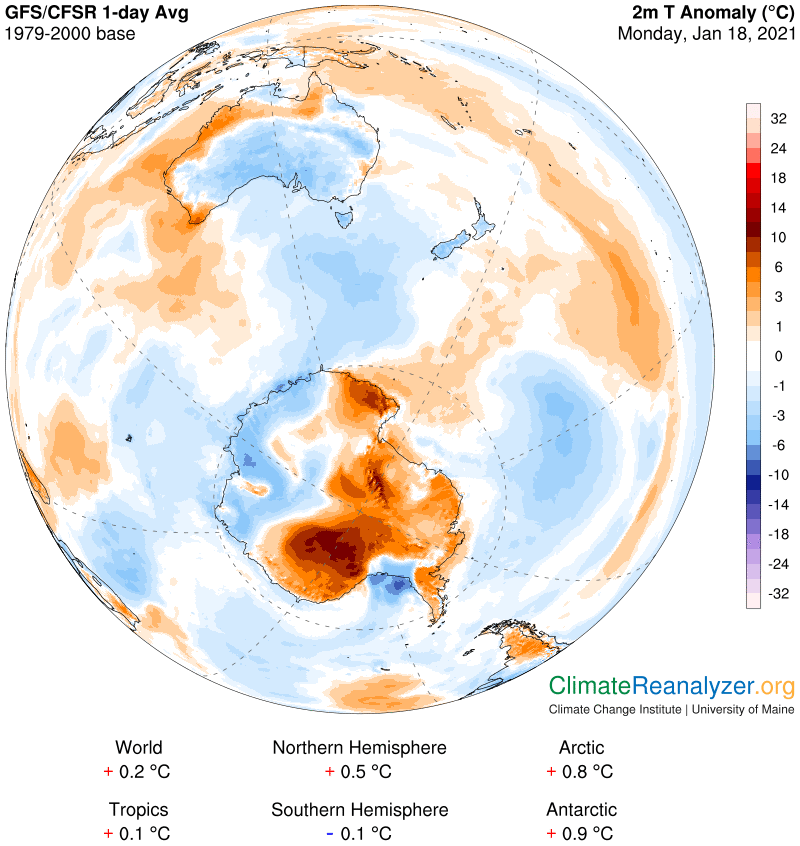
This cooling has helped bring the average NH temperature anomaly down to +0.5C from +1.0 just three days ago, for an unusually rapid rate for any kind of shift. It also leaves the World at just +0.2C, down from +0.4 and well off trend, in part because of La Nina cooling in the Pacific and the abnormally cool surface waters of the Southern Ocean. There was one more interesting development over the weekend that ran counter trend—a major warmup in the Antarctic, where the anomaly number has shifted from minus 0.7C to +0.9 in the last three days. There are specific reasons behind the change, and this time I can use visual aids, even making more use of the images recorded by fortunate chance in Friday’s letter, leaving them immediately available for reference. We’ll start with the 500hPa air pressure configuration, which has rather suddenly developed a less compact and more convoluted shape that is far from ordinary for this location by recent standards.
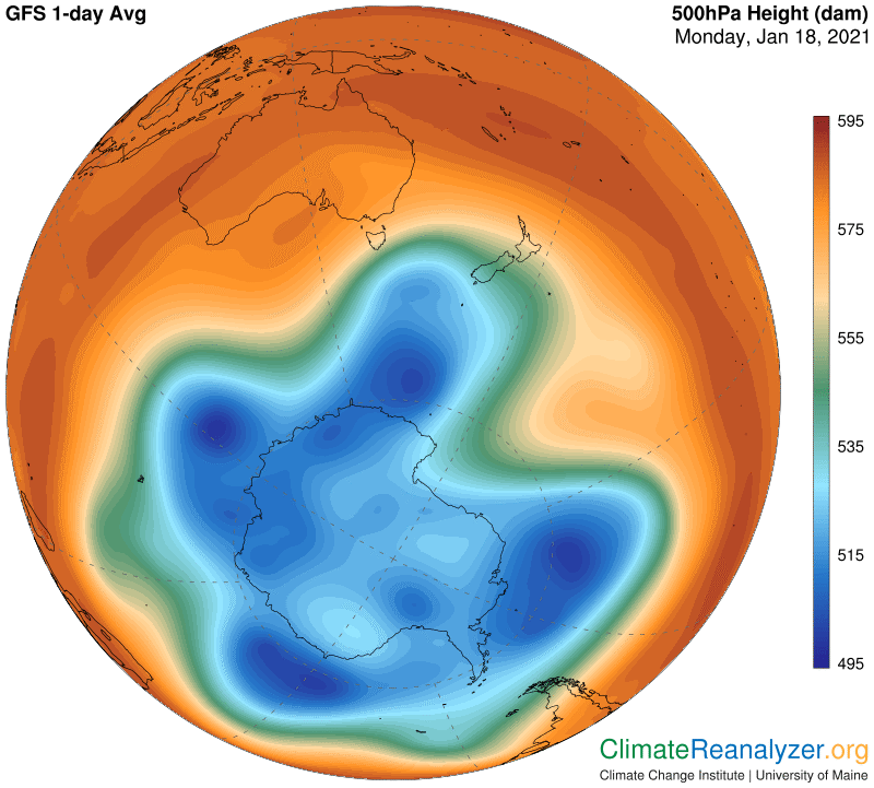
If you set the old and new images up side by side on your screen you can spot the details of a number of critical differences. The internal deterioration of the central blue zone is a key factor because it will expedite the movement of more PW directly into the heart of the continent, which in places is exceedingly dry and thus significantly exposed to upward leverage. You can also observe that the outer fringe of the blue zone and the similar fringe of the green zone, each of which is home to a major jetstream pathway, are now positioned in a state of less proximity than they were before, in certain sections. Any amount of separation weakens their ability to “pair up” and form a combined wind stream having maximum speed and strength. The result makes it easier for large-sized amounts of PW to encounter weak spots that are penetrable, especially in places of increased bending of wind stream pathways. This recording of today’s jet wind pattern shows an assortment of changes when compared to Friday’s:
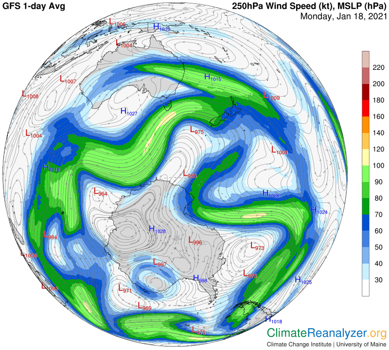
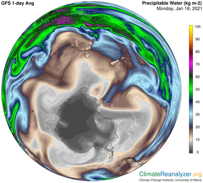
This activity sets up an assortment of opportunities for intrusions by PW, which can already be seen by close examination of this next image compared with Friday. I feel pretty confident that in days to come the intrusions will be even greater.
The last image discloses how great is the temperature change that has already occurred since Friday, as best indicated from an anomaly point of view. As a final note, the SH, unlike the current situation in the NH, has an abundance of new PW streams breaking away from the tropical zone each day, spaced out in a regular fashion around the globe. By implication, there is sure to be no shortage of PW approaching all parts of the continent at all times, well-positioned for making a deeper level of penetration whenever an opening is created. It will be interesting to see what follows in the days ahead as the general warming trend continues to unfold locally.
Carl