Are you ready for another demonstration of the power of precipitable water (PW) to alter surface air temperatures? Today we are getting a whole plateful of extreme-anomaly examples to work with on one single mapsite. I will shorten things up by not trying to do a full analysis on any of them, but you are welcome to do so on your own’ using magnification for best results. Actually, with this imagery we don’t need any magnification to see the tremendously strong relationship between PW values and temperature anomaly values. First the anomaly map:
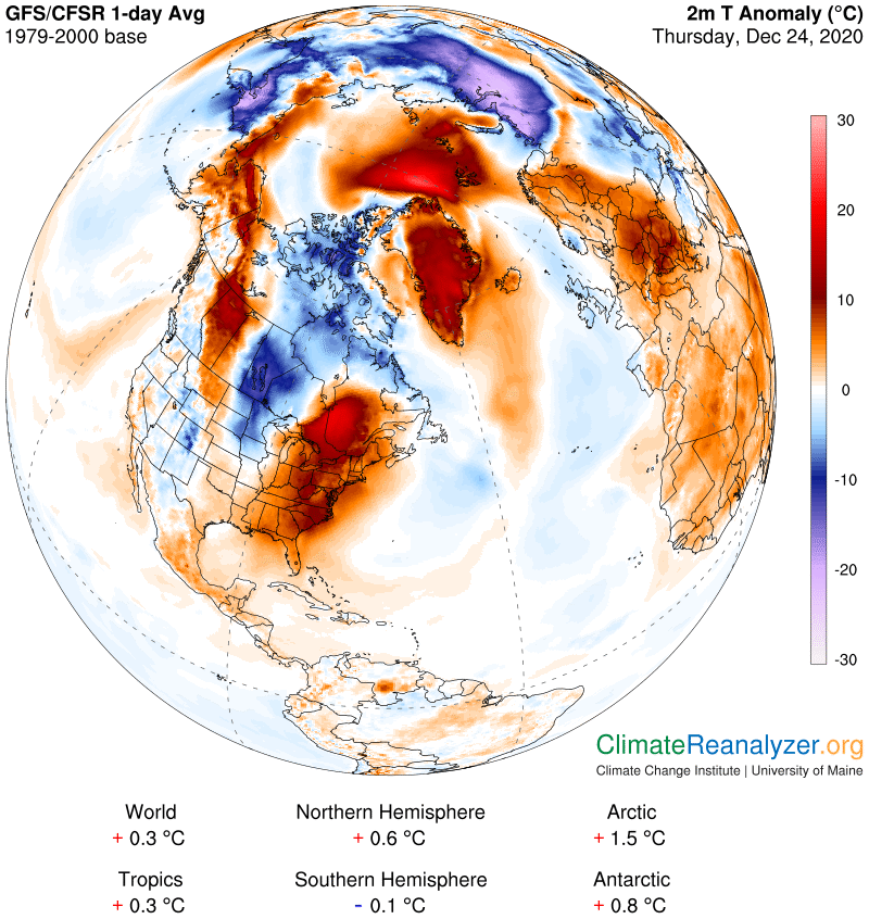
Two of the warm anomalies have reached the far-out extreme of +20C, or 36F, which is unusual but not rare. The large Siberian cold anomaly of -20C is actually quite rare, on the very edge of being an absolute maximum. Think about it—on just an average December 24th day in the past there was enough PW in the air to make the temperature 20 degrees warmer than it otherwise would have been, or just as we see it today. Where did that perfectly normal amount of PW come from in the past? Why is it now missing? Not too far away, in the middle of the iced-over Arctic Ocean, which has a winter climate no less cold than that of Siberia, we’re getting an equally large large area of +20C, for a total difference of 40 degrees C or 72F between the two. Could that mean real sensible heat is somehow being transferred physically from one place to the other? Or is there a large physical transfer of PW taking place from one atmosphere over to the other? Or could there be separate, outside sources of PW involved in both locations, sources that appear with regularity but contribute irregular amounts of PW to various local atmospheres on each daily appearance? Assuming there are no other options to consider, that’s the one I would pick. Let’s open the PW map:
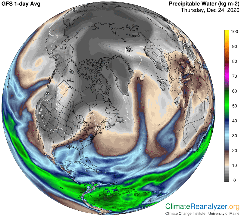
This map shows at least five tracks that can be interpreted (with an assist from the animated websites) as representative of ongoing active streams of PW formed from waters well to the south and making there way toward more northerly places. Every one of them seems to correspond quite closely with a region of warm anomaly as depicted in the top map. On the contrary, wherever the streams are not flowing on this particular day is consistent with places that are getting the coldest anomalies. Also, see how the farther north one goes the lesser is the amount of PW required to get a sizeable warm anomaly. And see how the relationships generally strengthen over land versus open ocean waters. And recall from the animated PW websites that this same map is sure to look somewhat different tomorrow, because of the ways those streams keep changing their courses and amplitudes.
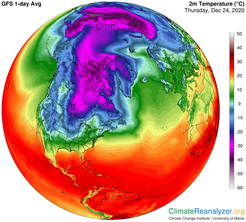
Now I’ll give you two more maps that you may want to use for references if you ever choose to do some further research of your own, following the principle that each logarithmic double of PW content adds about 10C to air temperature when everything else is either equalized for accountability or actually no different. Here are the real average temperatures for the day:
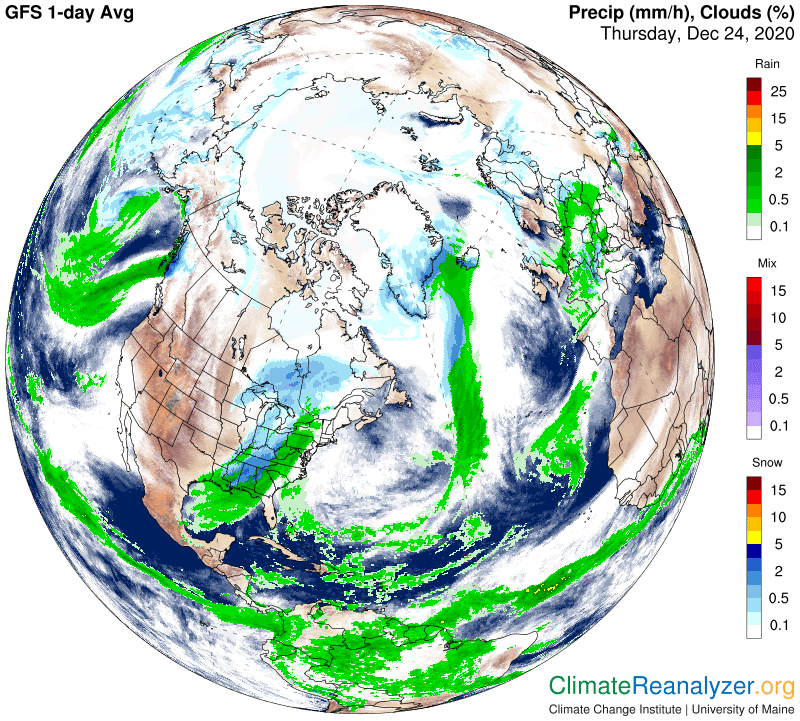
This last map is interesting for other reasons. For one thing you can see that the largest streams of PW often produce a great deal of precipitation. Weather reporters tell us everything there is to know about that side of the PW story. My only focus is on the temperature part, while purposely avoiding any discussion of warm or cold air masses moving around. I prefer to concentrate on PW’s implicit greenhouse energy factors, as a leading advocate of the observation that PW is Earth’s preeminent carrier of this kind of energy deliverance. Also, notice how some of the places that have the coldest temperature anomalies, like the ones in Siberia and the top of Canada, are displaying only a minimum amount of cloud cover. This is possibly a departure from normal, suggesting a condition where, in addition to causing the extreme cold, the low amount of vapor remaining in place is too little for new clouds to be formed.
Carl