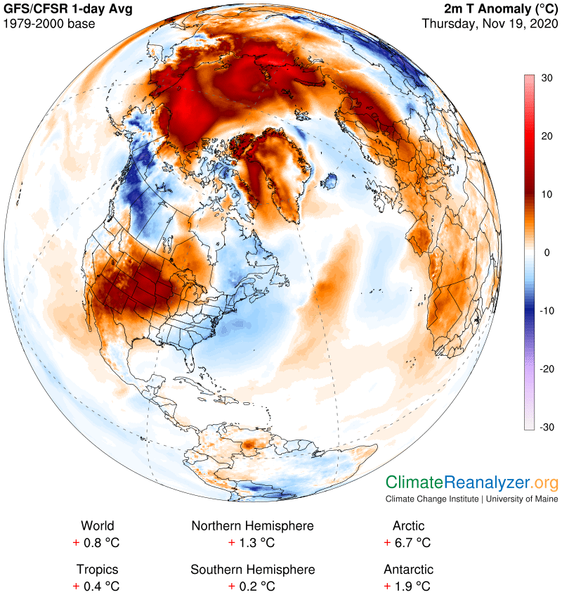
Update on the warming trend in the Arctic. On Monday the entire area within the Arctic circle was +5.4C and today it is +6.7. For the most part that is because Greenland is now under a new and separate source of pressure and has been converted from a cold to a warm anomaly. The ocean area by itself is now being hit hard by inflows of high-altitude water vapor coming from two different directions. We will be looking for the cause of all three of these situations, with an added note about the anomaly in the center of the 48 states.
The big problem for the Arctic, much the same as seen before, is tied to severe deformation of the upper-level air pressure configuration, particularly with respect to the shape of the blue zone as depicted on the next map. I’ll show it first and then talk about the consequences. Because Siberia lies close to the horizon on this map the hPa distortion in that area does not show up very well, but it runs nearly as deep as the loops in Alaska and Greenland on this side, and much broader. The most interesting deformity is the one over Alaska.
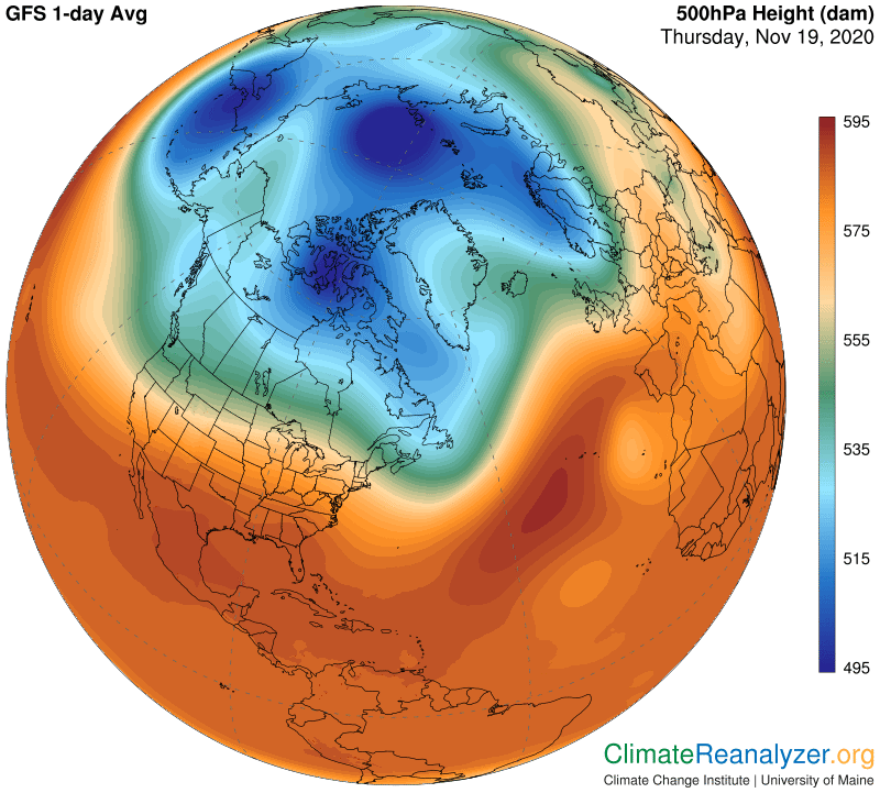
As discussed on Tuesday, the exact cause of all the hPa deformation is murky while its consequences are quite certain and predictable. Jetstream pathways must follow the contours of the isobars, which are all neatly color-coded, and when those contours become disordered or scrambled, like we see here, so too are the jet wind pathways that they govern. From a practical standpoint, whenever the pathways are disordered the winds they carry ware bound to fall out of their normal position and lose some of their normal strength. In fact maximum speeds only occur when portions of two of the three major pathways line up side by side in close proximity—which has a compounding effect on their individual speeds—and the frequency of those alignments tends to be less common in this situation. Also, whenever there is a sharp bend in a pathway the wind it carries will generally lose much of its speed at the apex of the bend.
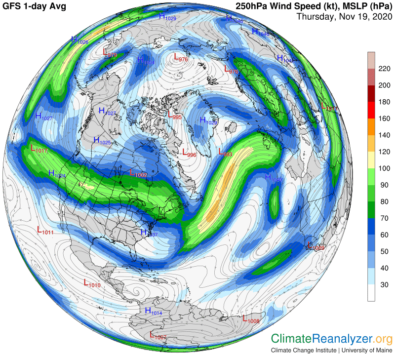
When concentrated streams of water vapor have entered the upper-level wind system, as discussed yesterday, seemingly intent on traversing toward the pole, any of those distortions and weaknesses occurring in jetstream wind formation tend to improve their chances of success. There may be more open spaces available between pathways, making for easy traverse, or they may find weak spots that can be penetrated. Or they may get picked up and carried along by a favorable jetstream wind that is temporarily moving on a poleward-slanting course. That type of wind will most likely make a bend at some point in order to reverse direction, losing strength in the process, allowing the vapor it carries to escape into an open space. There are examples of how all of these things work in this next image. My favorite is the vapor stream seen crossing the western edge of Alaska, through the Bering Strait, then up and around, carried by a weak jetstream wind circling the border of the hole we’ve seen in the 500 hPa blue zone. This particular vapor stream still contains enough abundance to produce an anomaly of the +20 type over a large part of the ocean when it disperses, practically matching the magnitude of warming on the Siberian side.
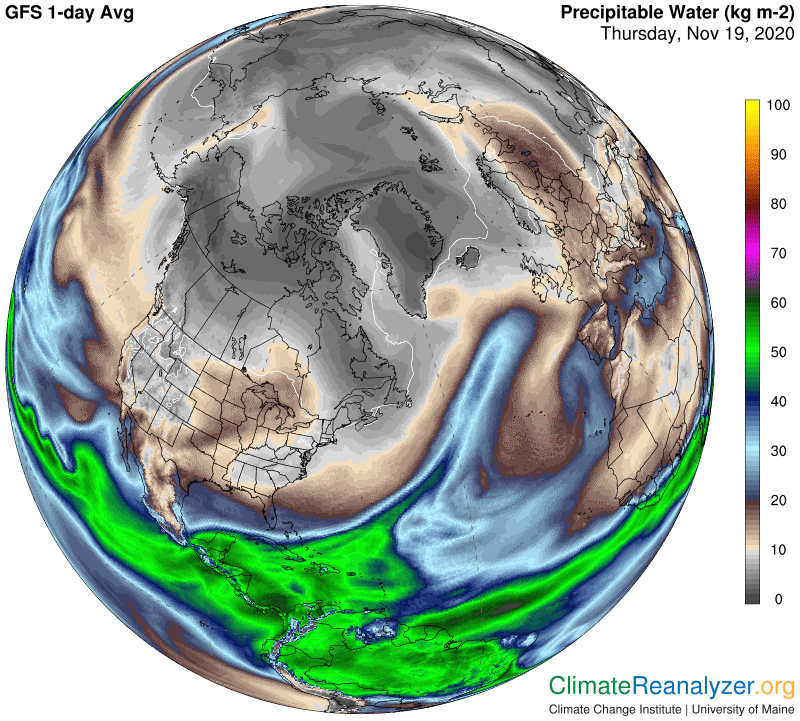
With respect to the warming in the center of the US, the animated website reveals that a large part of the extra vapor came in via a stream that has been passing through the states in the Pacific northwest. Waters off both coasts of Mexico also contributed, but I think to a lesser extent.
Carl