Today there is a fine example of the importance of water vapor as an agency of single-day temperature anomalies. It is happening in the Southern Hemisphere, where both Australia and Antarctica are exhibiting warm ones having considerable strength. We see them both on one of the regional maps, so let’s go there:
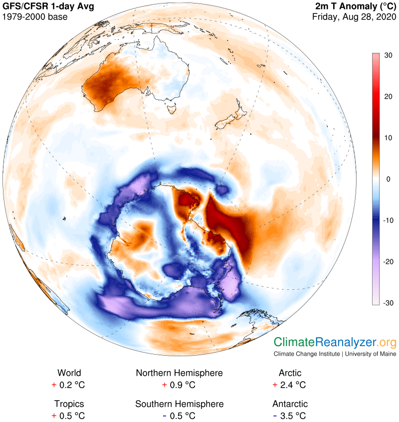
Each of these is neatly set apart from contiguous cool anomalies, or downright frigid in the case of Antarctica, so we will need to investigate whatever it is that might be responsible for the differences. Yesterday’s letter described several specific agencies that have this unique ability, by making relatively sudden shifts in behavior that can temporarily cause nearby temperatures to deviate from normal on short notice. One of these involves a change in cloud cover, especially low clouds. Another would be an intense level of rainfall—and I should have broadened that to include any kind of intense precipitation. Both of these agencies may be either present to some extent or not at all present on any given day, as indicated on this one weather map:
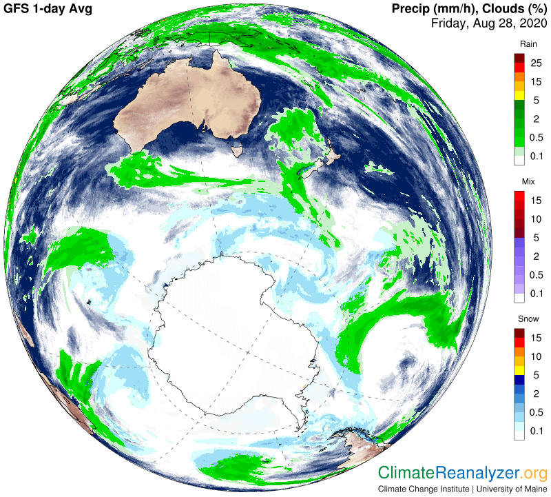
In the case of Australia there is absolutely no sign of either clouds or rain on any part of the entire continent. Since both of these agencies have a cooling effect when present, and since both could probably account for at least a little bit of cooling on an average day at this time of year, their complete absence entails the need to factor in a small amount of relative warmth in computing the current daily anomaly. This would equally affect all parts of the continent. The image from Antarctica doesn’t show anything at all in the way of clouds or precipitation. Clouds are actually present (see Windy.com) but can make no difference in temperature because there is so little sunlight at this time. I think it is just too cold for precipitation and can assume there really is no more than what the map is showing. It’s time now to have a look at the precipitable water map:
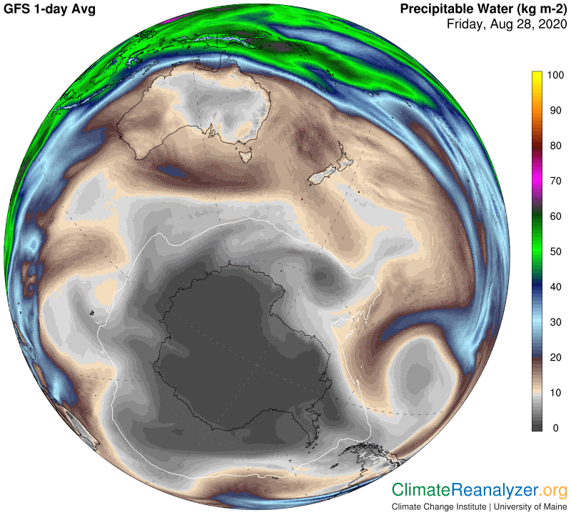
This one tells us everything we need to know. In the case of Australia, since there are no clouds at all and no other sign of condensation, virtually every bit of this “precipitable” water is in the form of pure vapor. On the warm half of the continent we can see an average of close to 15kg per square meter. That amount is almost certainly well above normal, even though there is no easily acquired data telling us what was normal some three decades ago, or for any other baseline. On the other side of the continent we see a common range of around 6-7kg, which is probably much closer to normal. These different amounts, roughly equal to a double, easily account for the difference in temperature anomalies that are revealed on the first map. Down in Antarctica, where everything is always exaggerated by the combination of extremely cold air and tiny water vapor numbers, we can see how water vapor levels that exist nearby at only around 1kg are being doubled up to two times in places by newly-active vapor intrusions. Each double is worth about an extra 10C in temperature readings down there, just like everywhere else, and quick swings like this one are not at all uncommon.
The several large cold anomalies in Antarctica still outweigh the one large warm one by a wide margin, They are a reflection of nothing more than a current absence of a normal amount of high-altitude water vapor intrusions similar to the one taking place where the warm anomaly has formed. Vapor streams that are in the surrounding area are now being effectively blocked off by jetstream winds positioned along much of the continental periphery. You can visit the animated website at http://tropic.ssec.wisc.edu/real-time/mtpw2/product.php for a real-time view of this activity. Note how different the situation is at the other polar region, where everything is unusually warm these days!
Carl