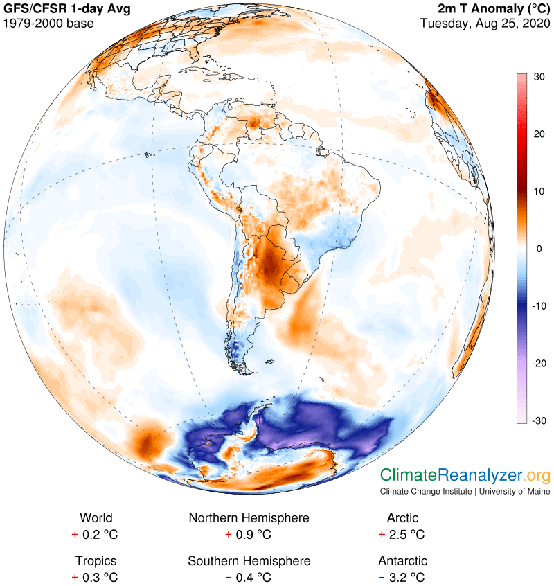
Late last week I devoted two letters (CL#1748-9) to analysis of a strong cold anomaly in South America. It was attributed to a combination of two completely different kinds of activity caused by the presence of a long and powerful burst of jetstream wind as it cut across the center of the continent. On the north side of the stream a massive amount of wind-borne water vapor was accumulating and condensing because the jet was blocking its customary southward movement. The dense clouds that were formed then proceeded to block sunlight from reaching the surface, thus causing an abnormal cooling of the air. On the south side the temporary absence of a normal amount of water vapor of this type was great enough to produce a remarkably similar anomaly via a reduction of the average amount of warming produced by the combined energy of all greenhouse gases—of which water vapor is far and away the strongest. Today there is an unusually strong warm anomaly showing up in the very same location, signaling that something of a quick and dramatic nature must have happened. Here it the new image:
The solution to this puzzle was not hard to find. In summary, the jetstream wind burst fell apart, leaving a gap through which the winds bearing water vapor could begin to flow again while immediately allowing the dense clouds to dissipate. On the south side a massive inrush of vapor has been great enough to not just overcome the cooling but also to produce more than the usual amount of greenhouse warming for awhile. The torrent due to the “dam burst” should soon subside. Let’s first take a look at today’s water vapor image, the location and shape of which are both noticeably different from what we saw in last Friday’s letter:
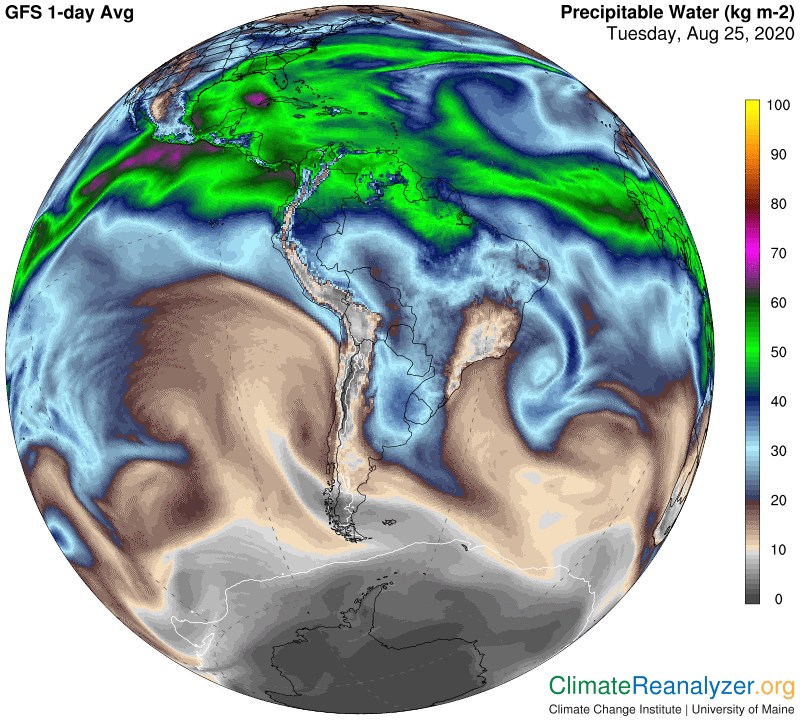
I believe the circle of light blue that you see contains about 40kg of vapor on its inside part, which should easily be enough to produce the close to 10C of anomalous warming that we see today in one spot on the top chart. Now we can proceed to do some analysis on the breakdown of the jetstream wind, which is a more complicated subject but I think a reasonable explanation of what has happened can be uncovered. Readers need to have a firm understanding of the relationship between the different jetstream pathways and their intermittent bursts of speed and of how pathways are precisely located within the configuration of upper-atmosphere air pressure differences, which is itself subject to various and continuous sources of change. These things are all explained and illustrated at length in previous letters. First, a view of the newly broken wind jet:
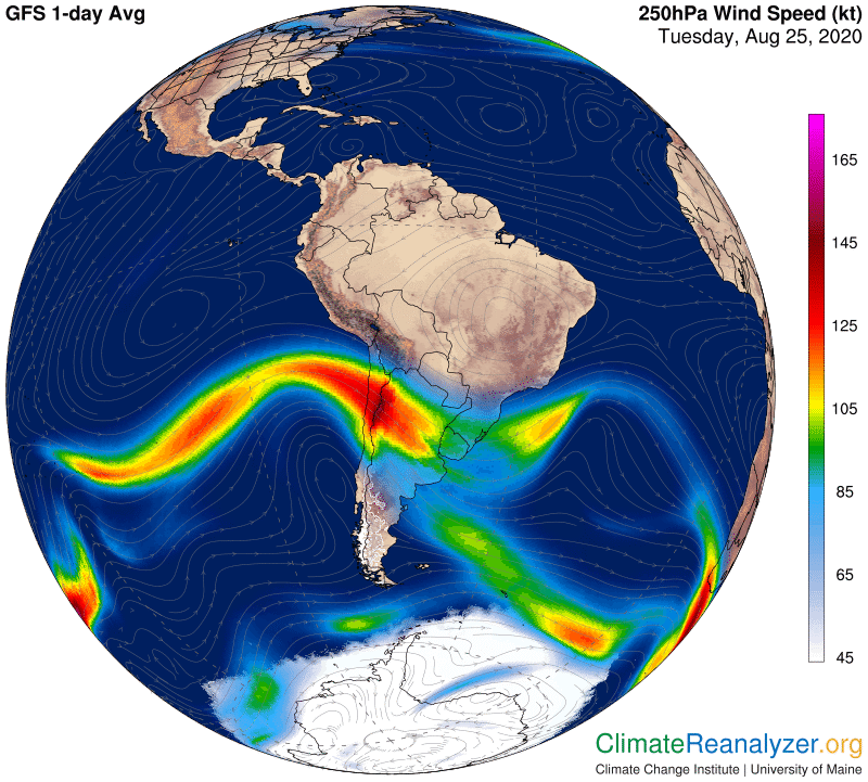
I wish I had displayed a closeup view from this angle in Friday’s letter, before the split, when it was even fatter, stronger and more extended than in the view shown on Thursday. What we had on those days was the near merging together of two pathways containing active wind streams, one in the red zone and one on the green fringe, side by side, close enough to cause a mutual acceleration effect in their wind streams. What caused this to break down was an abrupt shift in the shape of the configuration which forced the two pathways to move apart, putting an end to their wind speed acceleration, and leaving a weakness through which the vapor streams could immediately begin to advance. The two pathways are today widely separated, just where you would expect them to be when looking at this next image of current air pressure configuration:
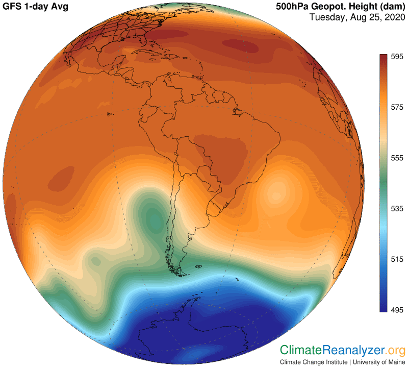
Why this particular and odd looking configuration change? I am now thinking the big and abrupt change in the dark red zone, observed in the form of a light red bubble shape just east of the continent, could have been instigated over the weekend as a “cooling” effect produced by the air pressure contraction of the very cold anomaly we were looking at on Friday. The spatial fit may not be perfect, but it’s close, and the size of the effect on air pressure configuration looks just about right. It would certainly have forced the jetstream pathways to separate when it happened. All things considered, this entire episode is composed of numerous phenomena of a type that really should get more attention in the science community, and made subject to a more rigorous analytical approach, by people who have more tools to work with. Of most importance, the effect of high-altitude streams of water vapor on single-day temperature anomalies cannot forever be ignored when it is so easily observed. Where will you find a better example than this one? It should at least become a matter of great scientific interest, if not concern.
Carl