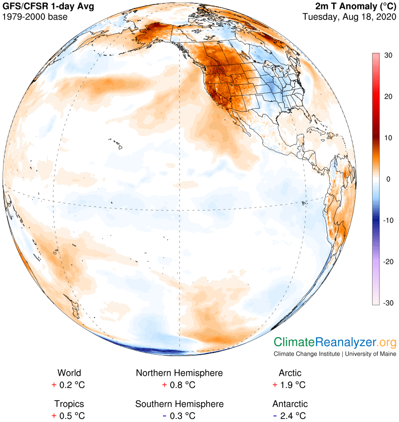
Today I was doing a follow-up study of the big warm anomaly reviewed in yesterday’s letter and learned something of considerable interest that I think is worth writing about. We’ll be using mostly the same images, updated by one day, with one change. The focus will be limited to a rather small region where everything comes together in a way that makes it amenable to reasonable explanation. We’ll start with the anomaly map, where I want you to focus on the bit of unusually warm signature around western Washington and northern Idaho and how it stretches out from there. Why that spot? I was only wondering what this small feature could mean upon comparison with the remainder of the overall anomaly:
The next map I looked at, for no special reason, was cloud cover, which turned out to be exciting because of the way a certain shape we looked at yesterday had now extended into an arc that seems to be sitting right on top of the warm anomaly spot and extensions observed in the first map:
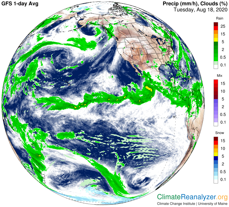
What was this cloud doing there in the first place, and how could its presence make air temperatures down at the surface any warmer than otherwise? So the next thing I did was to go over to the Windy website at https://www.windy.com/-Show—add-more-layers/overlays (Any picture you are seeing within it now will have changed because of the site’s animation.) Windy will break down cloud layers into high, medium and low, and will also show how high the tops are. There were no low clouds to be seen today anywhere over the entire warm anomaly, which is kind of interesting, and only a scattering of medium, but plenty of highs, which again were most dense in the spot of the arc. Cloud tops in this place were mostly in a range of 20-30,000 feet, or about four to six miles, which is known to be jetstream country, so why not look for any possible clues in the Jetstream map for today?
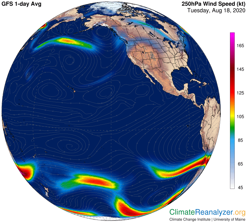
I was expecting to see something special, but this went way beyond my expectations. As you can easily see, the coincidence of a certain arc shape and the cloud arc shape above could not be more perfect. Things like this don’t happen by accident, and clouds don’t exist unless there is some water vapor handy to make them out of, so that means we should be seeking for still more clues in the map full of data on Precipitable Water:
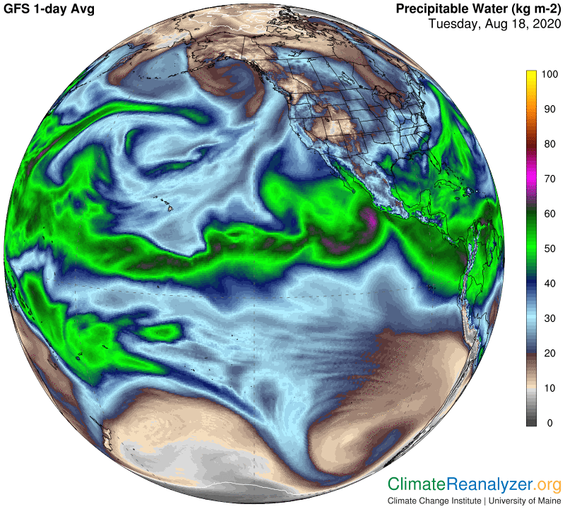
Another surprise. If you look carefully I think you will see how one stream of vapor, moving straight north along the California coast, narrows down and then makes a sharp bend to the right, gaining the shape of an arc that is positioned in the same exact spot where the arc of jet wind is blowing. So now we have three perfect arcs, one on top of another, positioned directly above some spots that happen to be noticeably warmer than most other parts of the warm anomaly. What can we make of such a strange phenomenon?
I have two main ideas in mind. First, I think that when the water vapor stream collided with the jet wind, and the latter held its ground, the vapor molecules would be obligated to pile up and widely condense by simple acts of compression. The numbers and distribution should be plentiful enough to explain the cloud formation, even opening up the eventual possibility of light rainfall which one can look for tomorrow. As for the anomaly effect, these clouds are probably not thick enough to block any of the incoming sunlight, but they still represent a thickening in the presence of water molecules. Water molecules in a gaseous state, as we all know, are responsible for exercising an exceptionally powerful greenhouse effect that blocks the flow of infrared energy as it heads out toward space from the surface. Here we actually have an intensified concentration of water molecules in place but fewer of them are still gaseous. This would suggest that being in a gaseous state may not be necessary for a substance to have its usual greenhouse effect, as long as it is able to absorb and remit radiation. I think we are seeing evidence of such activity now happening in the high clouds that have rolled out in this place.
Carl