Today, another exciting set of Weather Map images to look at. This time we’ll view the other side of the globe, where a massive portion of central Asia is experiencing temperature anomalies of 10-15C, with much more area being above 5C. The heat is not sweltering, but the amount of gain and size of area exposed to it, taken together, is truly extraordinary.
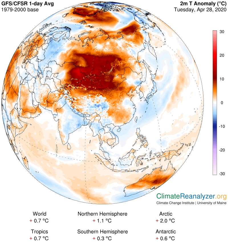
10-15C, almost 20-30F, is a lot of “extra heat” by any measurement, and it must have an equally large source. So where does all that heat come from? Maybe some kind of high BTU fuel, like sunshine? Only a little. Huge wildfires? None reported. Is the ground being heated from the inside? No way. A weird cosmic event? Etc., etc. Only one choice remains—it has to be the greenhouse effect we keep hearing about, on steroids. CO2 might have gone crazy, or maybe it was methane hydrates coming alive, these being the two most prominent greenhouse gases. Sorry, but there is one more gas, seldom mentioned, that is much stronger than these two, and this gas has some quirky cousins that have an even greater propensity for being overlooked by greenhouse watchers. The gas, and its cousins, are all just water, not quite the same as the kind we use so much of every day, but a specific variety, having mixed state, that I wrote about yesterday. Today I want to be even more specific and rename this material, calling it “high-flying airborne water,” in order to bring sharper focus to its location and mode of operation, which are separate and distinct from other varieties of airborne water, in particular with reference to its extraordinary global warming effect.
High-flying airborne water, or HFAW for short, mostly exists within a region up to several miles above the surface. Once there it likes to likes to stay in motion, with a bias favoring movement that is both eastward and toward either one of the poles. Moreover, instead of being evenly dispersed and spread out over the entire globe, such as we observe with all the regular long-lived greenhouse gases, HFAW tends to be bunched up, with a multiplicity of forms, and highly evanescent. Those bunches, in turn, tend to be very choosy about their places of birth, with a preference for warm, tropical seawater, or perhaps a tropical rainforest. Either way, from the moment of birth, as bits of vapor, their first movement is straight up, soon followed by a sorting out process where, over time, some of the vapor bits quickly start to condense, while others hang on as vapor for longer periods. Condensed or not condensed, the molecules of water that are born together, over a generation, tend to remain together and move together as one big family, often involving a coherent stretch of time as streams of movement are formed and persist. One and more of these streams provided all of the greenhouse effect required for production of the Asian heat anomaly shown above. There is no other option in sight. This next map offers an abundance of guidance showing how it has unfolded:
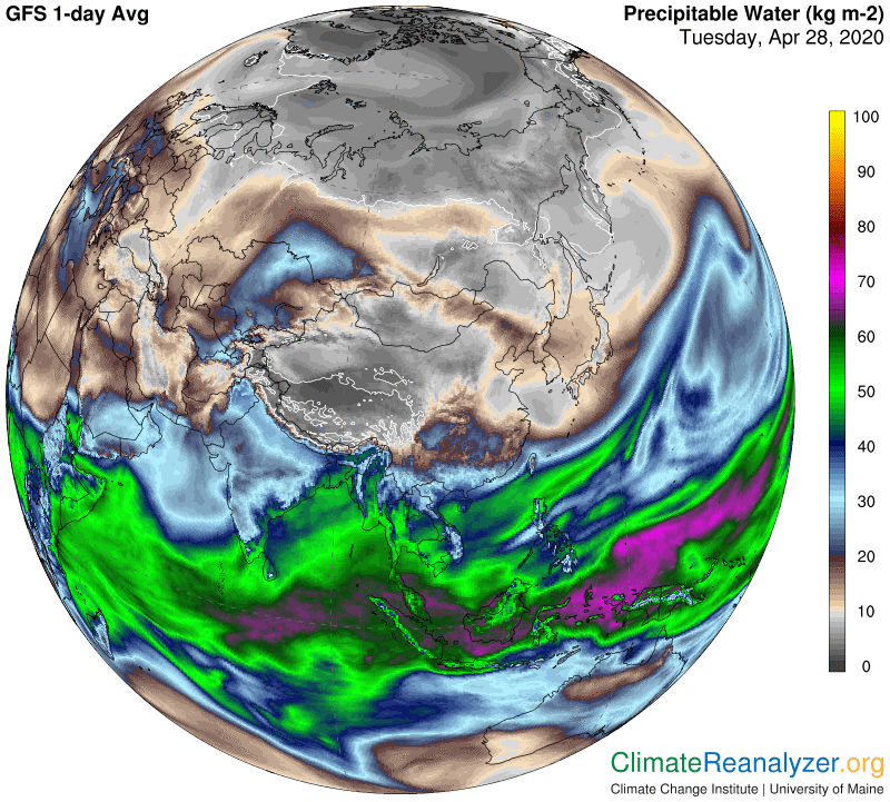
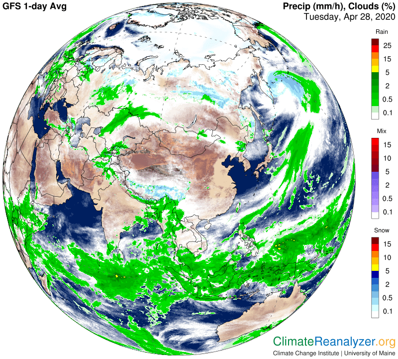
There are two really special things about this particular scenario that I need to discuss here, both of which are related to cloud cover. One is related to the birthplace of the principal HFAW stream creating the temperature anomaly. I believe it is rising from the Arabian Sea, and I also believe the amount of water being generated is greatly amplified by the fact that the Arabian Sea has for a number of days, including today, been almost perfectly free of clouds, as indicated on the map below. Moreover, the current temperature of this body of seawater right now is very warm, reaching 30C is some spots. (You can check out the status any time at https://climatereanalyzer.org/wx/DailySummary/#sst.) What this all means is that the evaporation rate must be very high and the vapor produced has no cloud-type barrier that would obstruct the movement of molecules into the upper altitude, where a stream can easily be formed and proceed. This condition could very well be seen as a vital component in maximizing the volume of HFAW streams anywhere. The Bay of Bengal also has some even warmer water under a clear sky, but of lesser area, that appears to be contributing a stream in the same direction. Also on the cloud map, see how much of the area on the receiving end of the stream is cloud-free, assuring a maximum of greenhouse effect under full sunshine. Yet the warming is still very high even in those places that have clouds and strong rain showers, which is kind of puzzling.
I have more to say about the overall content of HFAW and the nature of its powerful greenhouse effect, but maybe we’ve covered enough for today and can save that material for another letter.
Carl